Feeds:
Posts
Comments

R

No one will ever get out of this world alive.

Resolve therefore to maintain a reasonable sense of values.

Take care of yourself.

Good health is everyone’s major source of wealth.

Without it happiness is almost impossible.

Resolve to be cheerful and helpful.  People will repay you in kind.

Avoid angry, abrasive persons.  They are generally vengeful.

Avoid zealots.  They are generally humorless.

Be chary of giving advice.  Wise men don’t need it and fools wont heed it.

Resolve to be tender with the young, compassionate with the ages, sympathetic

with the striving and tolerant of the weak and the wrong.

Sometime in your life you will have been all of these.

Henry

Henry, the keeper of journals,

six thousand pages worth in his lifetime,

never worshiped, never voted, never plundered

probably never won any popularity contest

as the flaunting of his self-reliance

stirred up envy in his detractors

who struggled in their jobs to do the same

Henry nonetheless, was no hermit

as he made his daily trips into town

to partake in the village camaraderie;

albeit balancing with time in the woods

where frescoed paths through the wild world

seemed to him best tread in solitude

remaining ever alert to perpetual secrets,

marveled at! then taken home in his journals

Henry unabashedly passed on his secrets

in savy tomes that make us feel

we’ve walked those paths ourselves

@ j.Flaherty  2016

http://commons.digitalthoreau.org/tsag2016/thursday-july-7-2/a-first-transcription-of-thoreaus-field-notes-and-surveys/First transcription of Thoreau’s Field Notes of Surveys

Walter Brain was a close personal friend and mentor to many 

people who study the life  of Henry D. Thoreau, including myself.

He has touched and enriched all our lives and will be missed greatly.

Born in Lima, Peru in 1936, he attended universities in Lima

as well as the U.S., earning a Master’s Degree in Landscape

Architecture from Harvard University.  The Thoreau Society was

fortunate to have Walter’s and poems appear in in its quarterly

Bulletin as well as in the Concord Saunterer.  Walter also participated in

special events at Annual Gatherings and served as a member of its

Board of Directors.

Walter was a staunch advocate of the Walden Woods

Project and frequently expressed concern for the gradual loss of land

to the expansion of the new high school that he felt was infringing

on their edges.

As a practicing Landscape Architect he designed and

supervised construction of an elevated walkway across Concord’s

Mill Brook connecting Keyes Road parking lot and the rear of the

Christian Science Church in Concord Center.

A stickler for detail, Walter knew the correct names of plants

and animals, and knew many bird calls that he would emulate in the

field.  Frequently, when I was walking with Walter in the Town

Forest he would call out to the birds.  On one occasion I was quite

startled to see a great horned owl swoop from its nest and soar close

over our heads!  Walter only chuckled.

Walter was an advocate for Concord’s annual bird census

and an active participant in these events.  He often walked with Field

books containing plant names, photos and written descriptions so

that he could identify an unfamiliar plant on the spot.  During his

walks in the town  forest he also carried a walking stick that he used

with great relish to whack what he saw as invasive plants.  He also

carried field glasses and a camera to identify and record both

botanical and archeological discoveries.

He would point out “Jack in the Pulpit” flowers which he

frequently observed while walking n the Town Forest near the

home-site of Brister Freeman, a former Concord slave immortalized

in Elise Lemire’s outstanding book Black Walden.  Elise mentioned to me that Walter

first called to her attention the Brister Freeman

home-site initially recorded by Henry Thoreau on his survey maps.

Walter was understandably quite proud of and protective of his

discovery of the original dirt fence bounding the site.

Walter had knowledge of and concern for endangered

Concord plants such as the Calla Lilies that he pointed out growing

near my home adjacent to Cambridge Turnpike.  He was concerned

that they could be lost due to scheduled road widening.

Annual walks in the Town Forest were scheduled to

correspond to the annual Riverfest.  Walter’s availability for

participation would always depend upon the timing of his annual

visit with one or more of his three sons and grandchildren who live in

Boston, Munich and London.  He had his priorities straight.

Following our walks in the Town Forest Walter and I

typically returned to my home for lunch and a cold beer.  Walter also

enjoyed discussing with my wife his knowledge of a famous Spanish

poet (Jorge Guillen) whom she had as an instructor while a Spanish

major at Wellesley College.

In his poem “Home Trek,” Walter asks,

Am I going anywhere?

For I feel I’ve arrived, though never did I leave

And have been here all along, seduced by these fields.


For those of us who knew him, Walter will continue to be here, a

presence in the woods and fields he loved and worked to protect.


This article originally appeared in

The Concord Saunterer: A Journal of Thoreau Studies, N.S. Vol. 23, 2015


Thursday July 9, 2015, 1:30-3 PM, CFPL

Welcome to Workshop II

Thoreau Society’s 2015 Annual Conference

Thoreau’s Beck Stow’s swamp”

1 message

Julien Negre <julien.negre@ymail.com> Sun, Sep 7,2014 at 7:47 AM

Reply-To: Julien Negre <julien.negre@ymail.com>

To: “allanhschmidt@gmail.com” <allanhschmidt@gmail.com>

Good morning Allan,

I don’t know if you remember: we exchanged emails about a year ago about

the perambulation of Concord Performed by Thoreau in Sept., 1851.

I am writing today because I might need your help to solve another

cartographical mystery:

I am trying to locate “Beck Stow’s Swamp,” which Thoreau mentions several 

times in his Journal and manuscripts

(the passage I’m interested in is in *WildFruits*, p.166, but the name appears many times in his texts).

I have looked at two different maps and I’ve noticed that the swamp is not on

the same spot:

The first one is Herbert Gleason’s 1906 map.

http://www.concordlibrary.org/scollect/Gleason/Map.html


The other one is Brad Dean’s map included at the end of *Wild Fruits*:

BeckStowMap

this time, the swamp is south of Lexington Road, that is, just south of Hawthorne’s house

if I’m not mistaken.

I live in Paris, France, and, from that distance, it’s a bit hard for me to determine

if Dean’s second map is just plainly wrong. As a local resident and mapping

specialist, could you tell me where Beck Stow’s swamp is, exactly?

Thanks a lot for your help. Sincerely,

Julien Negre Universite Paris Diderot

<allanhschmidt@gmail.com>À : Julien Nègre <julien.negre@ymail.com>Envoyé le : Lundi 8 septembre 2014 21h30 

Objet : Re: Thoreau’s “Beck Stow’s swamp” 

Julien,

Thank you writing concerning Beck Stow’s Swamp I have attempted to contact the author of the book, Bradley Dean, but learned from the Thoreau Institute he passed away several years ago.

I am now trying to locate the author of the map, Theo Baumann.

I will let you know when I have more information concerning the differences related to the location of Beck Stow’s Swamp on Gleason’s 1906 Map of Concord and Baumann’s map of Thoreau country.

.Regards,

Allan

9/8/14

to me

Allan,

Thank you very much for your help and quick answer. Let me know if you learn something!

I noticed that on Walling’s 1852 map of Concord (available here: http://maps.bpl.org/), a swampy area seems to be indicated where Gleason located Beck Stow’s swamp.

Regards,

Julien

7/1/2015

Yes, that is possible.  However, Thoreau’s map of the New Road toward Bedford on which he located Beck Stow’s swamp was created in 1853. When Walling created his 1852 map of Concord he would not have had access to Thoreau’s 1853 map of his New Road toward Bedford on which he noted the location of Beck Stowe’s swamp by the intersection with what is today referred to as the Old Road to Bedford.

Allan

August 23,  I854. Vaccinium oxycoccus  has a small, now purplish-dotted fruit, flat on the sphagnum, some turned partly scarlet, on terminal peduncles, with slender thread-like stems, and small leaves, strongly resolute on the edges–of which Emerson says, the “Common cranberry of the north of Europe,” cranberry of commerce there.

October 17, 1859-These interesting little cranberries are quite scarce, the vine bearing (this year at least) only amid the higher and drier sphagnum mountains amid the lowest bushes about the edge of the open swamp, There the dark red berries (quite ripe, only a few spotted still) now rest on the shelves of the red sphagnum. There is only enough of these berries for sauce to a botanist’s Thanksgiving dinner.

I have come out this afternoon a-cranberrying, chiefly to gather some of the small cranberry, Vaccinium oxycoccus. This was a small object, yet not to be postponed, on account of imminent frosts-that is, if I would know this year the flavor of the European cranberry as compared with our larger kind. I thought I should like to have a dish of this sauce on the table at Thanksgiving of my own gathering. I could hardly make up my mind to come this way, it seemed so poor an object to spend the afternoon on. I kept foreseeing a lame conclusion-how I should cross the Great Fields, look into Beck Stow’s Swamp, and then retrace my steps no richer than before. In fact, I expected little of this walk, yet it did pass through the side of my mind that somehow, on this very account (my small expectation), it would tum out well, as also the advantage of having some purpose, however small, to be accomplished-of letting your deliberate wisdom and foresight in the house to some extent direct and control your steps.  If you would really  take a position outside the street and daily life of men, you must have deliberately planned your course, you must have business which is not your neighbors’ business, which they cannot understand. For only absorbing employment prevails, succeeds, takes up space, occupies territory, determines the future of individuals and states, drives Kansas out of your head, and actually and permanently occupies the only desirable and free Kansas against all border ruffians.  The attitude of resistance is one of weakness, inasmuch as it only faces an enemy; it has its back to all that is truly attractive. You shall have your affairs, I will have mine.   You will spend this afternoon in setting up your neighbor’s stove, and be paid for it; I will spend it in gathering the few berries of the Vaccinium OXYCOCCUS which nature produces here, before it is too late, and be paid for it also, after another fashion.  I have always reaped unexpected and incalculable advantages from carrying out at last, however tardily, any little enterprise which my genius suggested to me long ago as a thing to be done, some step to be taken, however slight out of the usual course.

Henry D. Thoreau

Wild Fruits

p. 164-167

De : Allan H .Schmidt<allanhschmidt@ @gmail.com>

A : Julien Negre<Julien.negre@ymail.com>

Envoye Ie : Jeudi 11 septembre 2014 18h23

Objet: Re: Thoreau’s “Beck Stow’s swamp”

Julien,

I have located Beck Stow’s Swamp on one of Thoreau’s Land Surveys on file at the Concord Free Public Library.

You may see it by going to: http://www.concordlibrary.org/scollect/Thoreau_surveys/7c/7c-c.jpg

and scrolling down the page.

Thoreau’s notation is right below the road intersection.

I found this reference in the Herbert Gleason Archives at the Concord Library.

So I would accept Gleason’s map but I have not yet identified the source for Brad Dean’s map, but still looking.

Regards,
Allan

Allan

On Fri, Sep 12, 2014 at 8:52 AM, Julien Negre wrote:

Allan, that’s fascinating, thank you very much. I didn’t expect to have the swamp mapped and located by Thoreau himself! I had a look at the volumes of the Journal of the Princeton edition and it is said that Theo Baumann’s map was made using Gleason’s map and modern USGS maps from 1950 and 1958. I had a look at those maps and the area around Mill Brook (south of Lexington Road) is depicted as swampy, whereas the area near the road intersection indicated by Thoreau is indicated as normally dry. That might be the reason why Baumann located the swamp there? Best,

Juilien

Julien Nègre <julien.negre@ymail.com>

De : Allan H. Schmidt <allanhschmidt@gmail.com>

À : Julien Nègre <julien.negre@ymail.com>

Envoyé le : Lundi 8 septembre 2014 21h30

Objet : Re: Thoreau’s “Beck Stowe’s swamp”


e: Thoreau’s “Beck Stow’s swamp”

message Fri, Sep 12,2014 at Allan H. Schmidt <allanhschmidt@gmail.com >

11 :17 AM To: Julien Negre <julien.negre@ymaiLcom> Bcc: Ellen Schmidt <eschmidt01742@gmail.com>

Julien,

You could be correct, the area where Beck Stow’s Swamp was located in Thoreau’s day is high and dry today (I drove by there this morning), although there is another swamp just a little further south known as Gowlings which was and still is wet.

What I find strange about the map in Dean’s book is that he completely
omitted Hawthorne Lane which connects Cambridge Turnpike and
Lexington Road and is bordered by the Mill Brook.

Gleason’s map is slightly in error in this area, showing the Mill Brook crossing Hawthorne Lane a bit further south than it did and does today. My wife and I walk that area every day.

Regards,

lof4 12/15/201410:42 AM

Dear Mr Schmidt,
Thank you for your letter that arrived as a complete surprise !
if my memory serves me right, i did that map 1967/68 in Christchurch, New Zealand.
As this is a lifetime in my past, i cannot remember from whom and what basic information i had at hand when drawing that map.
I am also not able to correct those omissions, as i have retired my pen and magnifying glass  !!
But what i find incredible to believe is HOW you could find my present address !?
You see, i have moved COUNTRIES and homes at least 20 times and been living at the present address for only one year !
Are you working with the CIA ???  Ha Ha !
Thanks again for your information,
and warmest (here it is presently 33C) Regards

Theo Baumann

Henry David Thoreau

High Blueberry

Some ten days later come the high blueberry, swamp blueberry, or bilberry.

We have two common varieties: (Vaccinium corymbosum and its variety, atrocarpum).  The latter, which is the least common, is small and black, without bloom, more acid, and a day or two earlier than the thimbleberry, beginning the first of July; and both last to September.  I notice the green berries by the thirtieth of May, and between the first and fifth of July begin to see a few ripe ones. They are at their height from the first to the fifth of August.

They are said to be found as far north as Newfoundland and Quebec. They grow in swamps, or if they are very wet, about their edges, and about the edges of ponds, and occasionally you meet a bush even on a hillside. It loves the water so much that though it may grow about the edge of a pond with steep and hard shores, like Walden and Goose Pond, it is confined strictly to the shoreline and will not bear well except in seasons when the water is high.  By the sight of these bushes, as of button bushes and some others in a hollow, you may know when you have gotten down to the water-level.  Let the ground in the woods sink to a certain depth so that water or considerable moisture is reached, and sphagnum and other water plants spring up there; and if man does not interfere, a dense hedge of high-blueberry bushes will commonly spring up around the edge, curving over it, or perhaps will extend through it, and this whether it is a mere hollow a rod across or a swamp of a hundred acres.

This is the commonest stout shrub of our swamps, of which I have been compelled to cut down not a few when running lines on a survey or in low woods.  When I see their dense curving tops ahead, I expect a wet foot.   The flowers have an agreeable, sweet, and berry promising fragrance and a handful of them plucked and eaten have a sub-acid taste, agreeable to some palates.  The fruit has a singularly cool and refreshing, slightly acid flavor; yet the botanist Pursh says of his (Vaccinium corymbosum, which must be another kind) simply, “berries, black, insipid.” In the Duc d’ Aremberg’s garden at Enghien, it is said to be “cultivated in the peat border for its fruit, which is used like that of the cranberry” so slow are they to find out what it is goof for!  Rarely I find some which have a peculiar and decided bitter taste, which makes them almost inedible.  They are of various sizes, colors, and flavors, but I prefer the large and more acid blue ones with bloom.   These embody for me the essence and flavor of the swamp.  When they are thick and large, bending he bushes with their weight, few fruits are so handsome a sight.

Some growing sparingly on recent shoots are half an inch or more in diameter, or nearly as big as cranberries.  I should not dare to say how many quarts I once picked from a single bush which I actually climbed.

These are not all that temp most into the swamps.  Annually we go on a pilgrimage to these sacred places, in spite of dogwood and bilberry bumps.  There are Beck Stow’s and Gowing’s and the Damon Meadows and Charles Mile’s and others, which all have heard of, and there are many a preserve concealed in the midst of the woods known only to a few.

Henry D. Thoreau

Wild Fruits

p. 30 & 31

J. Walter Brain


  1. J. Walter Brain

March 19, 1936 – April 19, 2015

Home Trek

On I trek the length of that grassy lane

Amidst green and misty rolling fields

And the far woods, a fieldstone wall by the side

Of the lane coasting along up and down hill

To the measure of my unwary, idle stride,

To the swing of my arms and the beating of my heart…

Am I now going anywhere?

For I feel I’ve arrived, though never did I leave

And have been here all along, seduced by these fields

And mists, a lonely elm past my trek,

A red barn looms farther on, the sky abloom

Mauve and rose, whether the first blush

Of day or eventide’s glimmer matters not,

My words echoing my footfalls all along.

  1. J. Walter Brain

You can find thirteen prior postings that reference J. Walter Brain since the inception of this blog  in April 2005 by using the WordPress search function in the upper right hand corner of the screen an searching for “brain”

WalterBrain

July 28, 2010


Thursday July 10, 2014, 2:15-3:45 PM, CFPL
Welcome to Workshop III, of The Thoreau Society’s 2014 Annual Conference

“Thoreau’s Illustrated Atlas” and “Thoreau’s Field Notes of Surveys”
Plus Charles Davies “Elements of Surveying and Navigation” as aids to decipher a letter to Thoreau from William Davis Tuttle concerning “Wheeler’s Lot” 1854

By Allan H. Schmidt

Summary:

This paper discusses surveying procedures for measuring land areas published by Charles Davies in the 1840’s and known to Thoreau and other surveyors.

Davies’ procedures are described in the context of an Excel spreadsheet and compared to Thoreau’s and Tuttle’s land area measurements of Wheeler’s Lot in 1854.

Thoreau’s likely use of a pantograph for copying maps at varying scale is discussed.

Thoreau’s use of a surveyor’s compass capable of recording angular measurements with greater precision than described in Davies’ tables provide an unique means for identifying surveys recorded by Thoreau.


The Correspondence of Henry D. Thoreau: Volume 1: 1834 – 1848
Edited by Robert N. Hudspeth
“This is the inaugural volume in the first full-scale scholarly edition of Thoreau’s correspondence in more than half a century. When completed, the edition’s three volumes will include every extant letter written or received by Thoreau–in all, almost 650 letters, roughly 150 more than in any previous edition, including some that have never before been published.
Correspondence 1 contains 163 letters, ninety-six written by Thoreau and sixty-seven to him. Twenty-five are collected here for the first time; of those, fourteen have never before been published. These letters provide an intimate view of Thoreau’s path from college student to published author. At the beginning of the volume, Thoreau is a Harvard sophomore; by the end, some of his essays and poems have appeared in periodicals and he is at work on A Week on the Concord and Merrimack Rivers and Walden. The early part of the volume documents Thoreau’s friendships with college classmates and his search for work after graduation, while letters to his brother and sisters reveal warm, playful relationships among the siblings. In May 1843, Thoreau moves to Staten Island for eight months to tutor a nephew of Emerson’s. This move results in the richest period of letters in the volume: thirty-two by Thoreau and nineteen to him. From 1846 through 1848, letters about publishing and lecturing provide details about Thoreau’s first years as a professional author. As the volume closes, the most ruminative and philosophical of Thoreau’s epistolary relationships begins that with Harrison Gray Otis Blake. Thoreau’s longer letters to Blake amount to informal lectures, and in fact Blake invited a small group of friends to readings when these arrived.
Following every letter, annotations identify correspondents, individuals mentioned, and books quoted, cited, or alluded to, and describe events to which the letters refer. A historical introduction characterizes the letters and connects them with the events of Thoreau’s life, a textual introduction lays out the editorial principles and procedures followed, and a general introduction discusses the significance of letter-writing in the mid-nineteenth century and the history of the publication of Thoreau’s letters. Finally, a thorough index provides comprehensive access to the letters and annotations.”
Source: front flap,”Volume 1, Thoreau Correspondence 1834-1848”
Robert N. Hudspeth is Research Professor of English at the Claremont Graduate University and professor emeritus of English at Redlands University. He is the editor of The Letters of Margaret Fuller and the author of Ellery Channing.
Review:
“Thoreau’s letters unquestionably enlarge understanding of his character. The personality who emerges is not just cold, impassive, and stoic but also witty, playful, and sociable, not just reclusive and idealistic but also engaged and practical.”—Choice

Vol. 1 “Thoreau Correspondence” 1834-1848 includes “the stagecoach letter”:
Concord, April 6, 1840
“Dear Haskins,
I improve this the first opportunity by sending your cloak by the Accommodation Stage.
…..
Yours,
Henry D. Thoreau”
Ref. The Correspondence, Volume 1: 1834-1848, page 65
The Writings of Henry D. Thoreau
2013
Princeton University press
Note:
The Concord Accommodation Stage made the seven hour round trip between Concord and 11 Elm Street, Boston, each day.
In his A HISTORY OF THE TOWN OF CONCORD, Lemuel Shattuck wrote, “Public Stages were first run out of Boston into the country through Concord, in 1791, by Messrs. John Vose & Co. There are now (1833), on an average, 40 stages which arrive and depart weekly, employing 60 horses between Boston and Groton, and carrying about 350 passengers; 150 have passed in one day.” William Shepherd (owner of Shepherd’s Hotel on Main Street) ran a line of stages between Concord and Boston from 1817. Stages also stopped at the Middlesex Hotel.
The railroad came to Concord in 1844. Until train travel became the dominant form of transportation, stagecoach lines and the hotels that served them did good business here

The project described below relates to a letter to Thoreau from William Davis Tuttle concerning “Wheeler’s Lot”. It began in response to a question I received from Beth Witherell, formerly President of the Thoreau Society (1996-2000) and currently Editor-in-Chief of Princeton University Press Editorial Board for The Writings of Henry Thoreau. Including (Three volumes of “Thoreau Correspondence”

Beth Witherell’s letter to me relative to The Correspondence, Volume 2 included a question about Thoreau and surveying.
From: Beth Witherell <witherell@library.ucsb.edu>
Date: Sun, Nov 3, 2013 at 6:03 PM
Subject: Questions about Thoreau and surveying
To: allanhschmidt@gmail.com
Dear Mr. Schmidt,
I’m the head of the Princeton Edition of Thoreau’s writings, and I’m a big fan of your work on Thoreau. The surveys have much more significance than most readers and scholars of Thoreau have realized, and between your Illustrated Atlas and the Field Notes and Pat Chura’s book they have become more accessible. I wish I had been able to get to the last couple of Annual Gatherings to hear you talk and to meet you. For a long time I went every year, but in the last five or six years family matters have kept me from traveling.
I’ve worked on Thoreau since 1974 and studying his manuscripts, in person and using photocopies, has given me an opportunity to see the wide range of his interests and competencies. I’ve also come to understand the interlocking relationships among the contents of the various manuscripts that are now physically separate, which you don’t have a way to think about if you have access only to published versions.
For example, a (particularly full) day’s work for Thoreau might include writing up several days’ worth of notes as Journal entries, beginning a survey, reading and copying extracts from part of the Jesuit Relations, and writing a letter to the Harvard librarian accompanying a couple of books he was returning via a friend. The Journal passages would be in a MS volume of the Journal, now at the Morgan Library; the survey notes would be recorded in his Field Notes of Surveys, now at the Concord Free Public; the Jesuit Relations extracts would be in one of his MS Indian Books, now at the Morgan; and the letter might now be in the Houghton.
The parts of Thoreau’s work for that day all affected one another; sometimes the cross-pollination is visible, as when he mentions a survey or the title of a book in his Journal, and sometimes it’s not. One of my goals in annotating the Journal and Thoreau’s letters is to reveal these relationships when they’re relevant, to show the cross-pollination.
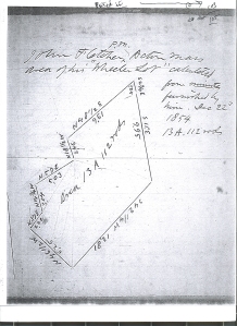
We’re working on Thoreau’s correspondence right now–the first volume of three was published August 1–and the annotations are sometimes interesting and quite complicated. I’m writing now to see if you can help me explain the contents of a letter to Thoreau from William Davis Tuttle which I am assuming is about the work Thoreau records on p. 105 of his Field Notes. On that page, above and to the right of a plan of a plot of land, Thoreau writes:
P. M.
John Fletcher^ Acton Mass
Area of his “Wheeler Lot” calculated
from minutes
Furnished by
him. Dec 22nd
1854
13A. 112 rods

To see the Image of Thoreau’s plot of Wheeler’s Lot in “Thoreau’s Field Notes of Surveys” go to http://allanhschmidt01742.wordpress.com/ and scroll down to page 105.

103


Tuttle’s letter to Thoreau follows–only one leaf of it survives:

“made a very small plan of it
(about 2 rods to an inch I should judge)
& cast it up making 14 A 22rods
The plan was so small (& so unskillfully drawn) that I told Mr. W that very
little reliance could be placed upon it in computing areas.
Since then I have computed the area
several times by the aid of traverse tables finding
the Lat & Dep both in chains & decimals of a chain
& in rods & dec of a rod & obtaining answers
the bearing of the 3d course N 57 E & taking out
the Lat & Dep in rods & decimals of a rod I made
the area to be 13a 109,57r. I find but little
(,01 of a rod) diff between the Eastings & Westings & but ,19
of a rod between the Northings & Southings. & in balancing
the survey I subtracted the Diff between the North &
Southings from the Southing of the 7th course.
Will you have the kindness to inform me by what
method you computed the Lat in question: if by
plotting to what scale your plan was drawn, or if by
the traverse table whether you took out the distances
in chains or rods & to how many decimal places
you found the Lat & Dep. of each course
What is your general method of computing
areas & what is the present variation of the needle in Concord?
Yours very respectfully,
Wm D. Tuttle”

I think Thoreau’s plan in the Field Notes (for 12/22/1854) and Tuttle’s letter is about the same lot because:
1) Tuttle indicates that if he uses “N 57 E” as the bearing of the third course he gets an area of 13 acres 109.57 rods, which is quite close to the area as Thoreau calculates it–13 acres 112 rods
2) In Thoreau’s drawing, the third dimension from the NE corner of the lot is labeled “N 57 E”. I’ve assumed that that third dimension is the same as Tuttle’s “3d course”
3) Tuttle refers to “Mr. W” and Thoreau says this is Fletcher’s “Wheeler Lot”
Last month, in Boston, Bob Hudspeth, the editor with whom I’m working on this volume, found the record for a transaction that I think involves this parcel: On December 14, 1854, James Wetherbee Wheeler of Acton sold a tract of woodland containing 14 acres, 28.5 rods to John Fletcher and Cyrus Dole of Acton. The price was $664.50.
I’d like to be able to date Tuttle’s letter, at least approximately, but I’ll have to use circumstantial evidence because the portion of the letter that survives doesn’t show a date. So my first question is whether I can reasonably assume that Thoreau’s record in his Field Notes and Tuttle’s letter and the record of the transaction are all about the same piece of land.
If they are, then I think I can assume that Tuttle worked for Wheeler (“Mr. W”), who supplied him with “a very small plan of [the lot] (about 2 rods to an inch I should judge)” which someone had “cast . . . up making 14 A 22 rods.” So that’s what Wheeler thinks the area is. In his letter Tuttle notes, “The plan was so small (& so unskillfully drawn) that I told Mr. W that very little reliance could be placed upon it in computing areas.” (I don’t think Tuttle went out and measured the lot–he mentions using traverse tables, which I think means that he used the data Wheeler gave him. Is that right?) Thoreau is working for Fletcher, who has furnished him with “minutes” that Thoreau has used to make his own calculations. Based on that data, Thoreau calculates the area to be smaller than Wheeler thinks–13 acres 112 rods. Tuttle wants to know how Thoreau arrived at his result.
In terms of dates, the sequence of events would be:
Before December 14, 1854, Wheeler engages Tuttle to calculate the area of the lot based on a small plan.
On December 14, Fletcher and Dole purchase the lot from Wheeler.
Between December 14 and December 22, Fletcher engages Thoreau to recalculate the area of the lot.
On December 22, Thoreau does that recalculation and records the result in his Field Notes.
After December 22, either Thoreau or Fletcher communicates Thoreau’s figures to Tuttle and Tuttle writes to explain how he made his calculations and to ask Thoreau how he did his.
Following this sequence, I’d date Tuttle’s letter “After December 22, 1854”. Does that seem supportable to you?
So that’s one set of issues this letter raises. Another is that Tuttle’s letter is packed with the vocabulary of surveying, which Thoreau obviously understood but which baffles me and will baffle most of our readers. I’ve found definitions of traverse tables and latitude and departure and chains and rods, but they don’t help me to understand the overall meaning of Tuttle’s letter. I think the best way to explain that would be to provide a brief explanation of what Tuttle is describing to Thoreau and asking Thoreau about. Could you write such an explanation to be used an annotation for this letter?
I’m sorry to say that I can’t offer you anything but credit for this work (I can send you a copy of Correspondence 1 now, and make sure you get Correspondence 2 and 3, which will save you several hundred dollars if you were planning to buy the books, but it’s not the same as a consultant’s fee, I know). You would be named as the author in the annotation itself, which will follow the letter, and you’d be listed in the Acknowledgments for Correspondence 2.
Thanks very much for persisting to the end of this long message. Whether it’s possible for you to respond to my questions or not, I do look forward to meeting you sometime.
Best,
Beth Witherell, Editor-in-Chief
The Writings of Henry D. Thoreau
http://thoreau.library.ucsb.edu/

My response of Nov/15/2014 to Beth Witherell’s letter follows:
Tuttle and Thoreau correspondence concerning “Wheeler’s Lot” 1854
Question: What is Tuttle describing to Thoreau and asking Thoreau concerning Wheeler’s Lot?
Answer: Tuttle is describing two different procedures he had used to measure the area of Wheeler’s lot and asking Thoreau’s opinion as well as Thoreau’s experience concerning a related issue of compass correction for magnetic variation in Concord.
Area measurement of a land parcel was a common statistic provided by Thoreau for the lots that he surveyed from 1837-1860. Many of the land parcels were described as “woodlots”. An area measurement could be used to calculate the amount firewood or building lumber and therefore dollar value that could be expected from a woodlot prior to its being cut.
According to a Surveyor’s Manual that was in Thoreau’s library (Davies, Charles “Elements of Surveying and Navigation”, 1846):See:
http://play.google.com/books/reader?id=KpVHAAAAIAAJ&printsec=frontcover&output=reader&hl=en&pg=GBS.PP5
There were two commonly used methods for computing land areas, given a map of known scale.
1. Divide the existing map of land lots into geometric units (e.g. squares and triangles) and then compute the area of each lot and sum their total area.
2. Noting the bearings and distances for each lot originally recorded with compass and chain, use rules of geometry and traverse tables to compute the area enclosed within the map perimeter.
(Both procedures were alluded to by Tuttle in his letter to Thoreau)
Davies notes that when using compass and chain there are two potential sources of error:
1st. Inaccuracy of the surveyor’s field observations when recording bearings and distances.
2nd. Local attractions or the derangement which a compass needle experiences when brought into the vicinity of iron-ore beds, or any ferruginous substances.
To guard against these sources of error, reverse bearing should be taken at every station: if this and the forward bearing are of the same value, the work is probably right; but if they differ considerably, they should both be taken again.
Differences between measurements taken in each direction also may be used to estimate “balancing” corrections.
THE TRAVERSE TABLE AND ITS USES
The Traverse tables that are included in Davies book, show the latitude (N-S) and departure (E-W) corresponding to bearings for each survey line segment expressed in degrees and quarters of a degree from 0 to 90°, and for every course from 1 to 100, computed to two decimal places.
By use of these tables the latitude (Y- coordinate) and departure (X-coordinate) of each course segment may be computed.
Davies describes how given a surveyor’s field measurements describing the straight line segments defining the perimeter of a property boundary, it also is possible to compute the area of the property in question and also create a graphic x-y coordinate plot of its perimeter.

Tuttle’s Letter to Thoreau follows (with my comments in italics):
Made a very small plan of it about 2 rods (i.e. 33 feet) to an inch (scale)
An enlarged copy of a map can be made by use of a pantograph, see: http://en.wikipedia.org/wiki/Pantograph
Thoreau owned such devices currently on display in the Concord museum and shown on their website. http://www.concordcolleection.org/ then do a word search in the Thoreau collection for “compass” and you will see Thoreau’s pantograph.

 Untitled-4 copy


I should judge & cast it up making 14 A 22 rods
(i.e. I manually drew an enlarged plot and divided it into geometric units (e.g. squares and triangles) then summed the area of each lot, resulting in an estimate of 14A 22 rods,= 14.14 A.)
The plan was so small (& so unskillfully drawn) that I told Mr. W that very little reliance could be placed upon it in computing areas.
Since then I have computed the area several times by the aid of traverse tables
(I next computed the area using the compass and chain technique described by Davies.)
Finding the Lat & Dep both in chains & decimals of a chain
& in rods & dec of a rod & obtaining answers
the bearing of the 3d course N 57 E & taking out
the Lat & Dep in rods & decimals of a rod I made
the area to be 13a 109,57r.
(resulting in an estimate of 13A 109.5722 rods, 13.69A.)
I find but little (,01 of a rod) diff between the Eastings & Westings & but ,19
of a rod between the Northings & Southings. & in balancing
the survey I subtracted the Diff between the North &
Southings from the Southing of the 7th course.
Will you have the kindness to inform me by what
method you computed the Lat in question: if by
plotting to what scale your plan was drawn, or if by
the traverse table whether you took out the distances
in chains or rods & to how many decimal places
you found the Lat & Dep of each course.
What is your general method of computing areas?
(i.e. Do you generally use plotting of geometric units or the Compass and chain measurements?
We know from a review of Thoreau’s Land Surveys that he used both techniques beginning with geometric units and moving on to compass and chain once he had acquired a survey compass.)
& What is the present variation of the needle in Concord?
The question concerning “the present variation of the needle in Concord” refers to difference between True North and Magnetic North that Thoreau typically included on the plots he made of his Concord area surveys, a process which Thoreau described in detail in his Field Notes of Land Surveys on Feb 7, 1851 on page 38.
For example Thoreau reported a Variation = 10’1/8W on his map of Oct. 3, 1853.
For a detailed description of how Thoreau measured the angular correction required between magnetic and geodetic north, see the discussion in chapter six of “Thoreau The Land Surveyor” by Patrick Chura. http://www.upf.com/book.asp?id=CHURA001
Charles Davies in the 1839 edition of his book points out that heat and cold affect the magnetic needle and that the same needle will at the same place indicate different line at different times of the day. The magnetic needle will continue to recede from the meridian as the day advances until about the time of highest temperature, when it will begin to return and at evening will make the same line as in the morning. This change is called the diurnal variation and varies during the summer season from one fourth to one-fifth of a degree.

Terminology references:
Traverse table operations: see p. 105 of Charles Davies “Elements of Surveying”
Traverse networks involved placing the survey stations along a line or path of travel, and then using the previously surveyed points as a base for observing the next point.
Balancing the survey see p. 109 of Davies
Fletcher’s question to Thoreau concerning methods for computing areas is indeed interesting, and two different methods for dong so are described in Davie’s book.
Thoreau’s had used gridded data for measuring the area of Isaac Watts’ Woodlot Nov. 1849.
Davies describes the use of traverse tables to estimate the area of a land parcel including corrections for surveyor error in the vector data plus procedures for traversing the survey perimeter as an error check.

An M.S. Excel spreadsheet shown below was used to organize, analyze and display vector data as per Davies for Wheeler’s Lot for the west meridian and then the east meridian:
  Untitled-1 copy

 Untitled-3 copy

Column A numbers each survey station as a separate row in the table.
Column B is reserved for entering a course designation for a survey line between two stations
In column C enter the bearing in degrees and minutes for each course
In column D enter the distance in chains and links for each course
In column E and F enter the difference in latitude N or S from the traverse table for each course
In columns G and H enter the departure E or W from the traverse table for each course
In columns I and J enter the balanced latitude N or s for each course
In columns K and L enter the balanced departure E or W for each course
In Column M enter the double meridian distance (DMD) for each course
In columns N and O enter the area+ or area – for each course
Traverse Table Data is shown in columns Q through U taken from Davies Handbook.
Column Q contains the course number
Column R contains the Station number
Column S contains the Bearing in degrees and minutes
Column T contains the Bearing latitude
Column U contains the Bearing departure

After entering all the distances in column D, compute the sum of the distance in chains
After entering all the differences in latitude and departure in columns E-H compute the sums for each column N+, S-, E+, W-
The latitude error is equal to the difference between N/S latitude sums and
The departure error is equal to difference between E/W departure sums
(Davies p. 109)
The half error in southing and easting is found by dividing each by 2
Column I and J balanced values are found by subtracting the half error values for each N/S latitude and E/W departure course values
The resulting sums for North-South sum of courses then are equal and balanced as are the East-West sums of courses
In doing so, we have distributed the differences between the outliers in the values for each course.

After the work has been balanced, we next calculate the Double Meridian Distance (DMD) of each course. (Davies p. 112)
For this purpose a meridian line is selected that passes through the most westerly station of the survey.
The West meridian is located at Station 6 and called the Principal Station and course 1 which begins at this point, the “first course”. It is marked with an asterisk (*)
Next we look for inconsistency in the data values by checking for equivalence when tracing the values when we attempt to link the values in a clockwise order. The linking process involves computing an estimated next value based upon the current, last, and next value in the sequence which should result in a complete return to the initial value in the chain if all entries are consistent. Due to the numerous values derived from various tables and calculations this is an essential step for quality control. It also is very time consuming to perform manually.
The following rules are used in computing the DMD for each course proceeding clockwise:
The DMD of the first course is equal to its departure = (1.46)
The DMD of the second course is equal to the DMD of the first course, plus its departure, plus the departure of the second course. (1.46 +1.46 -0.71 = 2.20)
The DMD of any course is equal to DMD of the preceding course, plus its departure, plus the departure of the course itself. (2.20 -0.71 +2.99 = 4.48) Course #3
(4.48 +2.99 -0.92 = 6.55) Course #4
(6.55 -0.92 +6.95 =12.58) Course #5
(12.58 +6.95 +0.07 = 19.60) Course # 6
(19.60 +0.07 +2.08 = 21.75) Course # 7
(21.75 + 2.08 -7.94 = 15.88) Course # 8
(15.88 -7.94 -3.97 = 3.97) Course # 9
The DMD of the last course should be equal to the departure of that course.
Note that the DMD value and the departure value for last course #9 is = 3.97 and thereby closing the loop.
A verification of the work is therefore obtained by comparing the DMD with the departure of the course.

Next we apply Davies rules for computing the area given the DMD of each course. Charles Davies in his book “Elements of Surveying & Navigation” (1846) describes a procedure for calculating land area on pages 110-114 .
1. Multiply the DMD of each course by its northing or southing, observing that like signs in the multiplicand and multiplier give plus in the product and unlike signs give minus in the product.
2. Place all the products that have a plus sign in one column and all the products that have a minus sign in another.
3. Add up the columns separately and take the difference: this difference will be double the area of the land.
Data for Wheeler’s Lot using Davie’s traverse tables results in a value = 267.44 Sq. Chains, = 13.37 A.
Thoreau reported 13A+112 Sq. Rods= 13.7A.
13.7-13.37= 0.33A diff
.33/13.7*100= 0.2A diff
. Tuttle’s estimate was 13+109.57/160 i.e. 13.6848 A. or 13.69A, almost same as Thoreau.


Unresolved questions:
On December 14, 1854, James Wetherbee Wheeler of Acton sold a tract of woodland reportedly containing 14.18A to John Fletcher and Cyrus Dole of Acton.
Who created the survey “minutes” and rough sketch describing Wheeler’s Lot before it was sold to Fletcher? Who provided the area measurement recorded with the lot sold by Wheeler to Fletcher?
I suspect Tuttle initially surveyed the nine points needed to establish the minutes and chain measurements for Wetherbee Wheeler.
From that Tuttle would have been able to create a crude sketch from which he estimated the total area by use of a grid to initially compute the area for Wheeler as 14.14A. That data could have been used as a basis for recording and selling Wheeler’s lot to Fletcher.
After Fetcher purchased the land, he may have asked for a second more accurate opinion about the lot area from Tuttle.
We do not know when Tuttle was initially contacted by Wheeler but it appears to be prior to Tuttle’s letter to Thoreau. Tuttle initially computed the area from a grid giving 14.13A. Subsequently Tuttle computed the area using traverse table area to be 13.69A. Tuttle clearly had an interest and experience in estimating the area of Wheeler’s lot by a variety of methods.
Shortly thereafter Thoreau estimated the area to be 13.70A.
Tuttle provided an estimate of 13.69A.using traverse table data, and he asked Thoreau what procedure he used to compute a value of 13.70A. Tuttle’s letter suggests he was aware of Thoreau’s interest in Wheeler’s lot area and seeking to compare results and procedures.
Thoreau implies that his estimate was calculated for Fletcher “from minutes furnished by him”, It is not known how Fletcher initially had obtained the minutes, possibly from Tuttle.
If Tuttle worked for Wheeler before he sold the property Tuttle may have computed the area and the minutes that appear on the deed that Fletcher acquired at the time of sale.
After the sale, Fletcher hired Tuttle to measure the property with greater accuracy at which time Tuttle computed the minutes from a field survey and computed the area. Fletcher then asked Thoreau for his opinion and gave Thoreau the minutes computed by Tuttle. Tuttle was aware of Davies’ procedures for measuring land.
Thoreau’s measurements always appear to have had at least one measurement finer than ¼ degree so they could not be used with Davies Traverse tables for measuring land areas. Thoreau’s measurements were to the precision of his instrument, not to the less precise requirements of Davies’ Traverse tables with angles no finer than ¼ degree.
Therefore, Thoreau’s field survey entry of Fletcher’s “wheeler’s Lot” for 12/22/54 was probably a description of Tuttle’s original data “from minutes furnished by him” i.e. furnished by Tuttle to Fletcher who furnished them to Thoreau. Thoreau was aware of Davies procedures and presumably could have applied them to compute the lot area with the coordinates he was given rather than coordinates he (Thoreau) had measured in the field. I doubt that the coordinates shown were measured by Thoreau.
Thoreau’s measurement of Fletcher’s lot by use of minutes is the only example I have found of a map attributed to Thoreau that would qualify for use of Davies traverse tables because all of Thoreau’s other maps included at least one coordinate measurement finer than ¼ degree increment, e.g. 1/8th, 3/8th, 5/8th, or 7/8th of a degree. Davie traverse data tables included coordinates only in ¼ degree increments.
The first example of a land survey by Thoreau that included survey coordinates appears to have been R. W. Emerson’s Woodlot and meadow by Walden Pond (that part contained within the Lincoln bounds) the woodlot being a part of what was known in 1746 as Samuel Heywood’s pasture “and deeded as such to his son Jonathan Taunier Surveyed March 1850 with unusual accuracy”. (Perhaps because this appears to be his first use an instrument that allowed Thoreau to record his coordinate’s measurements to 1/8th of a degree.)
http://www.concordlibrary.org/scollect/Thoreau_surveys/33.htm
Thoreau also notes the lot area to be13 Acres, 1.0 rods and 7 perches. (40 perch = 1 rod)
Although he obviously did not use Davies traverse tables, Thoreau may have plotted the area using a fine grid.
Tuttle’s letter to Thoreau indicates that Tuttle used Davie’s traverse table data but we cannot tell whether Thoreau used traverse table data or merely plotted a fine grid to estimate the Fletcher’s lot area.
As Tuttle said:
“Will you have the kindness to inform me by what method you computed the Lat in question: if by plotting to what scale your plan was drawn, or if by the traverse table whether you took out the distances in chains or rods & to how many decimal places you found the Lat & Dep of each course. What is your general method of computing areas?”
That is the question being asked of Thoreau by Tuttle.
Thoreau’s response is unknown.
If Thoreau were to use Davie’s traverse tables he would have needed to extrapolate values from the existing tables to be compatible with his measurements that included 1/8 degree values. Or Thoreau would have had to compute the traverse table values in a manner with which I am unfamiliar.
Thoreau and Tuttle worked jointly on one or more projects involving work by Thoreau in May 1859 and by Tuttle five years later in 1864.
see for example http://www.concordlibrary.org/scollect/Thoreau_surveys/150a.htm
The map was likely obtained from Tuttle and included in the Concord Public Library collection of Thoreau’s maps when they were assembled by his sister after Thoreau’s passing.
N.B. Notice the two parts of the survey with and without a 1/8th degree value as an indication of Thoreau’s and Tuttle’s contribution.(Thoreau’s work is on the north side of the road and Tuttle’s on the south.)
Thank Beth Witherell for suggesting and supporting this project.
Thank also Adrienne Donohue, Concord Museum Registrar & Collections Manager, for her assistance.
Thank the concord Free Public Library for providing space, equipment and access to Thoreau’s records.
The above comments will be posted on my blog, Thoreau’s Chronological Atlas https://aschmidt01742.wordpress.com/

Tuttle and Thoreau correspondence concerning “Wheeler’s Lot” 1854

Question:  What is Tuttle describing to Thoreau and asking Thoreau concerning Wheeler’s Lot?

Answer:  Tuttle is describing two different procedures he had used to measure the area of Wheeler’s lot and asking Thoreau’s opinion as well as Thoreau’s experience concerning a related issue of compass correction for magnetic variation in Concord.

Area measurement of a land parcel area was a common statistic provided by Thoreau for most of the lots that he surveyed from 1837-1860.   Many of the land parcels were described as “woodlots”.  An area measurement was used to calculate the amount firewood or building lumber and therefore dollar value that could be expected from a woodlot prior to its being cut.

According to a Surveyor’s Manual that was in Thoreau’s library (Davies, Charles “Elements of Surveying and Navigation”, 1846):See:

http://play.google.com/books/reader?id=KpVHAAAAIAAJ&printsec=frontcover&output=reader&hl=en&pg=GBS.PP5

There were two commonly used methods for computing land areas, given a map of known scale.

“1. Divide the existing map of land lots into geometric units (e.g. squares and triangles) and then compute the area of each of each and sum their total area.

2. From an existing map or field notes of the bearings and distances for each lot originally recorded with compass and chain, compute the area of each lot summing their total area.

(Both procedures were alluded to by Tuttle in his letter to Thoreau)

When using compass and chain there are two sources of error:

1st.  Inaccuracy of the surveyor’s field observations when recording of distance or angle.

2nd,. Local attractions or the derangement which a compass needle experiences when brought into the vicinity of iron-ore beds, or any ferruginous substances.

To guard against these sources of error, reverse bearing should be taken at every station: if this and the forward bearing are of the same value, the work is probably right; but if they differ considerably, they should both be taken again.

Differences between measurements taken in each direction also may be used to estimate “balancing” corrections.

THE TRAVERSE TABLE AND ITS USES

These tables which are included in the Davies book,  show the latitude (N-S) and departure (E-W) corresponding to bearings for each survey line segment expressed in degrees and quarters of a degree from 0 to 90°, and for every course from 1 to 100, computed to two decimal  places.

By use of these tables the latitude (angle) and departure (distance) of a course segment may be computed to any desired degree of accuracy.

Davies notes that given a surveyor’s field measurements describing the straight line segments defining the perimeter of a property boundary, it is possible to compute the area of the property in question and also create a graphic plot of its perimeter.

Tuttle’s Letter follows (with my comments in italics):

Made a very small plan of it about 2 rods (i.e. 33 feet) to an inch (scale)

An enlarged copy of a map can be made by use of a pantograph, see: http://en.wikipedia.org/wiki/Pantograph

Thoreau owned such a device currently on display in the Concord museum and shown on their website.

http://www.concordmuseum.org/henry-david-thoreau-collection.php

Within the Concord Museum Collection, go to: Catalog #:   TH0012E, Object Name:                Compass

I should judge & cast it up making 14 A 22 rods

(i.e. I manually drew an enlarged plot and divided it  into geometric units (e.g. squares and triangles)then  summed the area of each lot, resulting in an estimate of 14A 22 rods,.)

The plan was so small (& so unskillfully drawn) that I told Mr. W that very little reliance could be placed upon it in computing areas.

(I next computed the area using the compass and chain technique described by Davies.)

Since then I have computed the area several times by the aid of traverse tables

Finding the Lat & Dep both in chains & decimals of a chain & in rods & dec of a rod & obtaining answers

the bearing of the 3d course N 57 E & taking out the Lat & Dep in rods & decimals of a rod I made

the area to be 13a 109,57r. (resulting in an estimate of 13A 109.57 rods,.)

I find but little (,01 of a rod) diff between the Eastings & Westings & but ,19 of a rod between the

Northings & Southings. & in balancing the survey I subtracted the Diff between the North & Southings

from the Southing of the 7th course.

Will you have the kindness to inform me by what method you computed the Lat in question:

if by plotting to what scale your plan was drawn,

or if by the traverse table whether you took out the distances in chains or rods & to how many decimal places you found the Lat & Dep. of each course.

What is your general method of computing areas?

(i.e. Do you generally use the geometric units or the Compass and chain measurements?

We know from an review of Thoreau’s Land Surveys that he used both techniques beginning with geometric units and moving on to compass and chain once he had acquired a survey compass.

& What is the present variation of the needle in Concord?

The question concerning “the present variation of the needle in Concord” refers to difference between True North and Magnetic North that Thoreau typically included on the plots he made of his Concord area surveys, the procedure for which Thoreau described in detail in his Field Notes of Land Surveys on Feb 7, 1851 on page 38.

For example Thoreau reported a Variation = 10’1/8W on his map of Oct. 3, 1853.

Terminology references:

Traverse table operations: see p. 105 of Charles Davies “Elements of Surveying”

Departure ibid. p. 105

Balancing the survey see p. 109 of Davies

THE TRAVERSE TABLE AND ITS USES. ibid. p 19. This table shows the latitude and departure corresponding to bearings that are expressed in degrees and quarters of a degree from 0 to 90°, and for every course from 1 to 100, computed to two places of decimals. The following is the method of deducing the formulas for computing a traverse table; by means of these formulas and a table of natural sines, the latitude and departure of a course may be computed to any desirable degree of accuracy. P.105

Traverse (surveying)

Traverse is a method in the field of surveying to establish control networks. It is also

used in geodetic work. Traverse networks involved placing the survey stations along a

line or path of travel, and then using the previously surveyed points as a base for

observing the next point. Traverse networks have many advantages of other systems,

including:

1.  Less reconnaissance and organization needed.

2.  While in other systems, which may require the survey to be performed along a

rigid polygon shape, the traverse can change to any shape and thus can

accommodate a great deal of different terrains.

3.  Only a few observations need to be taken at each station, whereas in other survey

networks a great deal of angular and linear observations need to be made and considered.

4.  Traverse networks are free of the strength of figure considerations that happen in triangular systems.

5.  Scale error does not add up as the traverse is performed.

Click to access traverse.pdf

Fletcher’s question to Thoreau concerning methods for computing areas is indeed interesting, and two different methods for dong so are described in Davie’s book.

Balancing   the survey’s 7th course to which he refers likely reflects the fact that the 7th course is also the longest at 12.81 chains of the 9 courses and potentially subject to variation over its length compared to other shorter courses.

Although both Thoreau and Wheeler arrive at approximately the same area measurement value i.e. 13.7 A and 13.5 A respectively, Davies procedure for area measurement suggests a more precise value to be 13.45 A.

Wheeler’s first measurement by casting up or enlarging a small map and then summing a grid overlay resulted in a value of 14A+22R. = 14.13A

Wheeler’s second measurement applying Davies’ procedures produced 13A+109.57R=13.68A

Thoreau’s measurement of 13+112R = 13.70 may have been derived from the work done by Wheeler, we will never know but Thoreau and Wheeler reported the same value and both are different from Davies’ presumed correct value by an identical amount.

The reason for the approximately 2% difference I suspect is due to the time required to carry out Davies procedures manually with pencil, paper, traverse tables and logarithms rather than computers and spreadsheets.

Although additional precision was possible the 98% accuracy level was adequate.

If Thoreau ever responded to Wheeler we do not have a copy.

Thoreau may have accepted Wheeler’s measurements and included them in his Field Notes of Surveys.

T said 13A + 112R = 13.7A, a difference of only +2R more than Wheeler but +40R over Davies

13.7A-13.45A=.25A        .25/13.45=.018 =+1.8% T greater than D

W said 13A + 110R = 13.68A

D said 13A +72R = 13.45A

Note: R = 1 square rod, 160 R = 1 A

Tuttle December 22, 1854

-6.66Letter from William Davis Tuttle to Thoreau dated December 22, 1854

Area of Wheeler Lot initially measured by Tuttle on an enlargement by plotting produced 14 A. 22R.

Area of Wheeler’s Lot subsequently measured by Tuttle using traverse table produced smallest value of 13A 11.9 R plus other values up to 13A 106.5 R.

Thoreau calculated the area of John Fletcher’s of Acton,” Wheeler Lot” from minutes  furnished by Fletcher, Dec. 22, 1854 and who estimated the area to be 13A 112 R.

Tuttle’s initial estimate by plotting = 14A 22R.

Tuttle’s several estimates by traverse table range from 13A 11.9R to 13A 109.57R.

Thoreau’s estimate calculated from minutes = 13A 112R. (largest of Traverse estimates)

Davies’ traverse table procedure says area correct value = 13A 72R.  See: https://docs.google.com/spreadsheet/pub?key=0AroG1WG-7zJ-dDN2emNRWGF0UDdJQk9WeUZLQkM4bEE&output=html

Thoreau’s area estimate is 1.8% or a quarter acre greater than Davies’.

Note that resulting Thoreau’s estimate of 13A 112R is within 98.2% of Davies rules as described by him and incorporated in an Excel spreadsheet above.

The data Thoreau used from Davies Tables are only given to two decimal places.

Thoreau could not assume greater precision in his result than in his data and if he were to compute all of the values required by Davies Rules it would be time consuming process involving pencil, and paper,  reference tables,  and logarithm tables.

I assume Thoreau had many other interests he pursued and the time required to compute the Area value to an additional decimal that required would not be warranted.

Davies’ tables were only given for quarter angle increments and would not have been applicable to most of Thoreau’s because every survey with exception of the Wheeler Lot shown above that involve a 1/8th degree angle specification by Thoreau in the Bearing specification.

However Thoreau may have computed the values required using the same equations Davies used in preparing the tables.

Measurements with chains were said to be precise to plus or minus one link in 100 (the length of the chain). I.e. 1 %

Credits for the above research project go to Beth Witherell witherell@library.ucsb.edu who suggested and funded the project.
Concord, April 6, 1840

“Dear Haskins,

I improve this the first opportunity by sending your cloak by the Accommodation Stage.

…..

Yours,

Henry D. Thoreau”

 Ref. The Correspoondence, Volume 1: 1834-1848, page 65

The Writings of Henry D. Thoreau

2013

Princeton University press

Note:

The Concord Accommodation Stage made the seven hour round trip between Concord and 11 Elm Street, Boston, each day.

In his A History of the Town of Concord, Lemuel Shattuck wrote, “Public Stages were first run out of Boston into the country through Concord, in 1791, by Messrs. John Vose & Co. There are now (1833), on an average, 40 stages which arrive and depart weekly, employing 60 horses between Boston and Groton, and carrying about 350 passengers; 150 have passed in one day.” William Shepherd (owner of Shepherd’s Hotel on Main Street) ran a line of stages between Concord and Boston from 1817. Stages also stopped at the Middlesex Hotel.

The railroad came to Concord in 1844. Until train travel became the dominant form of transportation, stagecoach lines and the hotels that served them did good business here.